UNESCO Upper Middle Rhine Valley: 40 Medieval Castles in 65 km of World Heritage Gorge
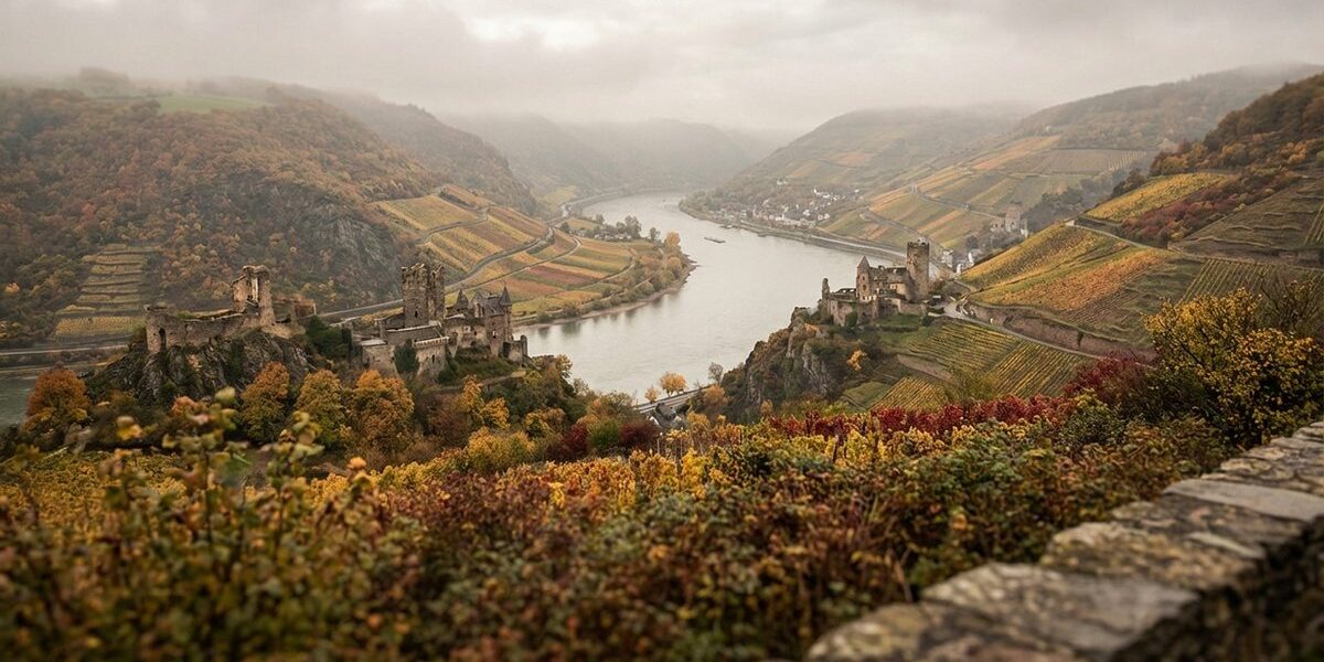
Between Koblenz and Bingen, the Rhine cuts through a narrow gorge flanked by forested hills, terraced vineyards, and an extraordinary concentration of medieval architecture. In 2002, UNESCO inscribed this 65-kilometre stretch as a World Heritage Site — the first German cultural landscape to receive the designation. The reason was simple: nowhere else in Europe do roughly 40 castles, palaces, and fortresses crowd so closely along a single river corridor (Source: UNESCO, 2002).
Why So Many Castles in So Little Space?

The answer lies in geography and economics. The Middle Rhine gorge is narrow — in places, the river is barely 200 metres wide, hemmed in by steep slate cliffs rising 100 to 200 metres above the water. During the medieval period, from roughly the 11th to the 14th century, this topography made the gorge a natural chokepoint for river traffic.
Local lords, prince-bishops, and imperial administrators built castles on every commanding hilltop and promontory, not primarily for military defense but for toll collection. Each castle controlled a stretch of river where ships could be forced to stop and pay. At the peak of the toll system in the 13th and 14th centuries, a merchant barge travelling the full length of the gorge might encounter more than a dozen toll stations. The resulting revenue funded the construction of ever more elaborate fortifications.
The system eventually collapsed under its own weight. Emperor Rudolf von Habsburg and his successors attempted to curb the toll lords, and by the late medieval period, the economic model had shifted. But the castles remained, perched on their hilltops like a geological stratum of feudal ambition.
Notable Castles of the Upper Middle Rhine
While all 40 structures contribute to the UNESCO designation, several stand out for their historical significance, state of preservation, or sheer dramatic setting.
| Castle | Location (Rhine km) | Built | Key Feature |
|---|---|---|---|
| Marksburg | Braubach (km 580) | ~1117 | Only hilltop castle on the Rhine never destroyed; fully preserved medieval interior |
| Burg Rheinfels | St. Goar (km 557) | 1245 | Once the largest fortress on the Rhine; withstood a siege by 28,000 troops in 1692 |
| Pfalzgrafenstein | Kaub (km 546) | 1327 | Island toll castle in the middle of the Rhine; never conquered |
| Burg Katz | St. Goarshausen (km 557) | ~1371 | Built to counter Burg Rheinfels across the river; overlooks the Loreley |
| Burg Maus | Wellmich (km 554) | ~1356 | Named “Mouse” as a rival to “Cat” (Katz); pioneering use of round towers |
| Burg Stahleck | Bacharach (km 544) | ~1135 | Now a youth hostel; panoramic views over Bacharach and the Rhine |
| Stolzenfels | Koblenz (km 585) | ~1242 / rebuilt 1836 | Neo-Gothic reconstruction by Karl Friedrich Schinkel; icon of Rhine Romanticism |
| Ehrenbreitstein Fortress | Koblenz (km 591) | 1817–1828 | Second-largest preserved fortress in Europe; overlooks the Deutsches Eck |
| Burg Sooneck | Niederheimbach (km 537) | ~1100 | Robber baron castle destroyed by Rudolf von Habsburg in 1282; rebuilt in 19th century |
| Burg Lahneck | Lahnstein (km 585) | 1226 | Guards the confluence of the Lahn and Rhine; privately owned and open to visitors |
This table covers a selection. The full UNESCO zone includes approximately 40 structures of varying types and preservation states.
Beyond the Castles: A Cultural Landscape
UNESCO did not inscribe the Upper Middle Rhine Valley solely because of its castles. The designation recognizes a cultural landscape — a combination of natural topography and centuries of human activity. Three elements are equally important:
- Terraced vineyards. The steep, south-facing slate slopes have been cultivated for wine since Roman times. Riesling grapes dominate, and the wines produced here are among the most distinctive in Germany. Maintaining these terraces requires enormous manual labor; their survival depends on continued viticulture.
- Historic towns. Small towns like Bacharach, Oberwesel, St. Goar, and Boppard retain medieval street plans, half-timbered houses, and churches dating to the Romanesque and Gothic periods. Oberwesel alone has 16 surviving defensive towers from its medieval town wall.
- The Rhine gorge itself. The geological formation — a river cutting through Devonian slate and quartzite over millions of years — created the dramatic terrain that made the castles possible and the Romantic painters famous.
Threats and Preservation Challenges
World Heritage status has not shielded the valley from pressure. The Rhine gorge is simultaneously a UNESCO site, a major shipping corridor carrying roughly 200,000 vessels per year (Source: WSV), and a vital rail link — the left and right bank railway lines together form one of Europe’s busiest freight corridors. Noise from trains, especially at night, has been a persistent complaint from residents and a point of tension between transport needs and heritage preservation.
Depopulation presents another challenge. Young people leave the small valley towns for larger cities, and the labor-intensive vineyard terraces are at risk of abandonment. Maintaining a single hectare of steep-slope vineyard requires up to 1,500 hours of manual labor per year — roughly ten times what a flat-land vineyard demands. As the economic viability of these terraces declines, so does a key element of the cultural landscape.
Climate change adds a further dimension. Rising temperatures are altering the conditions that have defined Rhine viticulture for centuries. Some winemakers report that Riesling, traditionally a cool-climate grape, is ripening earlier and producing higher sugar levels than in previous decades. Whether this represents an opportunity or a threat depends on the pace and scale of change — but the landscape the Romantics painted is not static.
The German government and the state of Rhineland-Palatinate have invested in noise reduction measures, cultural funding, and infrastructure improvements. The Bundesgartenschau 2029 (Federal Garden Show), planned for the Middle Rhine Valley, is intended to bring investment and attention to the region. But balancing economic development with heritage protection remains an ongoing negotiation.
Visiting the UNESCO Upper Middle Rhine Valley
The valley is accessible by car, train, boat, and on foot. The Rheinsteig (right bank, 320 km) and Rheinburgenweg (left bank, 200 km) hiking trails connect the major sites. River cruise ships and public ferries offer views from the water, and regional trains stop at most towns along both banks. The KD Rhine line operates scheduled passenger services between Koblenz and Mainz throughout the tourist season, and the journey through the full gorge takes approximately five hours downstream.
For those with limited time, the most castle-dense section lies between St. Goar and Bacharach (roughly Rhine km 557 to km 544). In this 13-kilometre stretch alone, you pass Burg Rheinfels, Burg Katz, Burg Maus, and the Loreley cliff — a concentration of landmarks that justifies the UNESCO designation on its own.
The UNESCO designation covers the stretch from Koblenz (Rhine km 591) to Bingen/Rüdesheim (Rhine km 526). For context on the Rhine’s full course and its geographic sections, our geography overview explains how the Middle Rhine fits into the river’s 1,232.7-kilometre journey from the Alps to the North Sea.
Forty castles in sixty-five kilometres. It sounds improbable until you stand in the gorge and see them appear, one after another, on every bend and bluff. The Upper Middle Rhine Valley is not just a collection of historic buildings — it is a landscape that tells the story of medieval power, Romantic rediscovery, and the ongoing challenge of preserving a living heritage alongside one of Europe’s busiest waterways.
Sources & References
- UNESCO: Upper Middle Rhine Valley — 40 Castles in 65 km
- UNESCO Germany: Deutsche UNESCO-Kommission