Rhine Tributaries: The Largest Rivers Flowing into the Rhine — Aare, Moselle, Main & Neckar
Every river is the sum of its tributaries, and the Rhine is no exception. What starts as a modest Alpine stream at Tomasee grows into Europe’s busiest inland waterway largely because of the rivers that join it along the way. The most surprising of these is the Aare: at their confluence in Switzerland, the Aare actually carries more water than the Rhine — 560 m³/s versus roughly 440 m³/s (Source: CHR, 2015). In hydrological terms, one could argue that below this point, the Rhine is really the Aare under an assumed name.
The Major Tributaries at a Glance
| Tributary | Length (km) | Catchment (km²) | Mean Discharge (m³/s) | Confluence Point | Side |
|---|---|---|---|---|---|
| Aare | 288 | 17,779 | 560 | Koblenz (CH) | Left |
| Moselle (Mosel) | 544 | 28,286 | 328 | Koblenz (DE) | Left |
| Main | 524 | 27,292 | 225 | Mainz | Right |
| Neckar | 362 | ~14,000 | 145 | Mannheim | Right |
| Ill | 217 | ~4,760 | — | Near Strasbourg | Left |
| Lahn | 245.6 | 5,964 | 52 | Lahnstein | Right |
| Ruhr | 219 | 4,485 | 81 | Duisburg | Right |
| Lippe | 220 | 4,882 | 45 | Wesel | Right |
| Sieg | 155 | 2,832 | — | Bonn-Beuel | Right |
| Nahe | 125 | 4,065 | — | Bingen | Left |
| Maas (Meuse)* | 874 | ~33,000 | 357 | Rhine delta (NL) | — |
* The Maas/Meuse merges with Rhine distributaries in the Dutch delta. Its status as a Rhine tributary vs. independent river is historically debated. Sources: CHR, 2015; Wikipedia; ICPR.
The Aare: The River That Outflows the Rhine
The Aare is the Rhine’s most important tributary by a single measure that trumps all others: water volume. Rising in the Bernese Alps and flowing 288 km through the Swiss Mittelland, the Aare drains 17,779 km² — roughly the entire northern flank of the Swiss Alps. By the time it reaches its confluence with the Rhine at Koblenz (not to be confused with the German Koblenz), its mean discharge of 560 m³/s exceeds the Rhine’s own flow at that point.
The Aare’s catchment includes the glaciers of the Jungfrau region, Lakes Thun and Brienz, and the Swiss capital Bern. Its heavy Alpine runoff drives the Rhine’s pronounced summer discharge peak in the upper sections — snowmelt from the Aare basin accounts for a significant portion of the Rhine’s flow at Basel (1,040 m³/s), where the two rivers’ combined waters head north (Source: BfG/Undine). Further upstream, the Rhine itself passes through Lake Constance before the Aare joins.
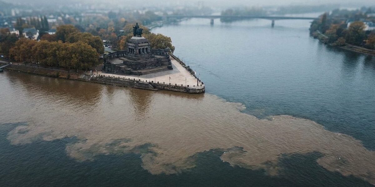
The Moselle: Wine Country and Western Europe
At 544 km, the Moselle (Mosel in German) is the Rhine’s longest tributary. It rises in the Vosges mountains in northeastern France, flows through Luxembourg, and joins the Rhine at the famous Deutsches Eck (German Corner) in Koblenz — one of the most photographed river confluences in Europe.
The Moselle drains 28,286 km² across three countries, making it the tributary with the largest catchment area after the Maas. Its 328 m³/s mean discharge reflects a rain-fed regime that peaks in winter — contrasting with the snow-fed summer peaks of Alpine tributaries. The Moselle valley between Trier and Koblenz is one of Germany’s premier wine regions, with steep, south-facing slate slopes producing world-class Riesling. The steep gradient of these vineyards — some exceeding 65 degrees — makes them among the steepest cultivated slopes in Europe.
The Main: Connecting the Rhine to the Danube
The Main is 524 km long and drains 27,292 km² of central Germany — Franconia, parts of Hesse and Thuringia. It joins the Rhine at Mainz with a mean discharge of 225 m³/s. But the Main’s significance extends far beyond its water contribution.
Since 1992, the Main-Danube Canal has connected the Main to the Danube, creating an unbroken 3,500-km waterway from the North Sea to the Black Sea. This canal, running 171 km between Bamberg and Kelheim and climbing to 406 meters above sea level, is one of Europe’s most ambitious engineering projects. It allows barges to travel from Rotterdam to the Romanian port of Constanța without leaving inland waterways.
The Main is also notable as a temperature indicator. Its waters are warmer than the Rhine’s (it lacks glacier input), and mixing at the confluence near Mainz creates visible temperature boundaries tracked by environmental monitoring stations.
The Neckar: Through Stuttgart to Mannheim
The Neckar rises in the Black Forest and flows 362 km north and west through Stuttgart and Heidelberg before joining the Rhine at Mannheim. Its catchment of roughly 14,000 km² includes one of Germany’s most industrialized and densely populated regions. Mean discharge at the mouth is 145 m³/s (Source: CHR).
The Neckar is navigable for 203 km between Plochingen and Mannheim, managed through a chain of 27 locks. The river corridor houses major automotive manufacturers (Mercedes-Benz, Porsche) and chemical companies, making water quality a persistent concern — though conditions have improved significantly since the 1970s. Historically, the Neckar was so polluted that fish had virtually disappeared by the 1960s. Today, thanks to decades of wastewater treatment investment, over 30 fish species have returned.
The Neckar confluence at Mannheim is a striking visual event. The darker, warmer Neckar water meets the greenish Rhine in a visible mixing zone that extends several hundred meters downstream. I have watched this confluence many times from the Mannheim riverbank, and the color contrast between the two rivers remains unmistakable even from a distance.
The Right-Bank Trio: Lahn, Ruhr and Lippe
Three smaller right-bank tributaries join the Rhine in its lower course, each with distinct character:
- Lahn (245.6 km, 52 m³/s): Rising in the Rothaar Mountains, it joins the Rhine at Lahnstein near Koblenz. The Lahn valley is popular for canoeing and kayaking.
- Ruhr (219 km, 81 m³/s): Gives its name to the Ruhrgebiet, Europe’s largest urban agglomeration. Once one of the most polluted rivers in Germany, the Ruhr has been extensively restored and now supplies drinking water to roughly 4.6 million people.
- Lippe (220 km, 45 m³/s): The northernmost significant right-bank tributary, joining the Rhine at Wesel. Its floodplains are among the most important wetland restoration sites in North Rhine-Westphalia.
The Left-Bank Contributors: Ill, Nahe and Sieg
On the left (western) bank, the Ill (217 km) drains the Alsatian plain in France and joins the Rhine near Strasbourg. The Nahe (125 km) enters at Bingen, marking the transition from the Upper Rhine to the Middle Rhine gorge. The Sieg (155 km), despite being right-bank, is notable as one of the most important salmon restoration rivers in the Rhine system — returning Atlantic salmon spawn in the Sieg and its tributaries each autumn (Source: ICPR, 2024).
How Tributaries Shape the Rhine’s Discharge
The cumulative effect of the Rhine’s tributaries is visible in its discharge data. At Basel, after the Aare has joined, mean discharge is 1,040 m³/s. By Kaub, after the Neckar and Main have entered, it reaches 1,640 m³/s — a 58% increase. At Cologne, with the Moselle’s contribution, it is roughly 2,090 m³/s. And at Lobith, after the Ruhr, Lippe and other Lower Rhine tributaries have added their flow, the full Rhine carries 2,210 m³/s (Source: BfG/Undine).
This growth pattern also explains why the Rhine’s flood risk increases downstream. A major rain event in the Moselle catchment can coincide with snowmelt peaks from the Alpine tributaries, creating compound flooding at Cologne or the Lower Rhine. The ICPR’s flood risk management plans explicitly model these tributary interactions, treating the Rhine as a system rather than a single channel (Source: ICPR, 2024).
The tributaries also determine the Rhine’s water temperature profile. Alpine-fed rivers like the Aare deliver cold, glacier-influenced water. The Main, by contrast, carries warmer water from central Germany’s lowlands. Where these streams meet, temperature gradients form that affect fish habitat, dissolved oxygen levels and the behavior of invasive species. Environmental monitoring stations at major confluences track these mixing zones continuously.
The Maas Question
The Maas (Meuse) deserves special mention. At 874 km and 33,000 km², it is longer and has a larger catchment than any Rhine tributary. Its mean discharge of 357 m³/s exceeds that of the Moselle. Yet the Maas does not actually join the Rhine in the traditional sense — it merges with Rhine distributaries in the Dutch delta, and whether it is a Rhine tributary or an independent river has been debated for centuries. The EU Water Framework Directive treats the combined Rhine-Maas system as a single international river basin district (IFGE), covering roughly 200,000 km² (Source: ICPR).
Why Tributaries Matter
Each tributary reshapes the Rhine. The Aare transforms it from an Alpine river into a Central European one. The Neckar and Main add the runoff of Germany’s industrial heartland. The Moselle brings rainfall from France and Luxembourg. By the time all tributaries have joined, the Rhine at Lobith carries 2,210 m³/s — nearly ten times its discharge at the Aare confluence. Without its tributaries, the Rhine would be a regional Swiss river. With them, it is Europe’s most important waterway.
For the broader picture of Rhine geography, visit the geography hub. To understand how these waters are shared politically, see 9 countries share the Rhine.