The 7 Rhine River Sections: Alpine Rhine, Upper Rhine, Middle Rhine & More

Walk along the Rhine at its source and you hear a mountain stream crashing over boulders. Stand at its mouth and you watch ocean-going container ships slide through a flat, engineered delta. In between lie seven distinct sections, each shaped by different geology, climate and centuries of human intervention. Understanding these sections is the key to understanding the Rhine itself.
Overview: Seven Sections at a Glance
| Section | Length | Start → End | Gradient | Key Cities | Mean Discharge |
|---|---|---|---|---|---|
| 1. Alpine Rhine | ~90 km | Reichenau → Lake Constance | Steep (~2.5 m/km) | Chur, Vaduz | ~230 m³/s |
| 2. Lake Constance | — | Bregenz → Stein am Rhein | Flat (lake) | Konstanz, Bregenz, Friedrichshafen | — |
| 3. High Rhine | 141 km | Stein am Rhein → Basel | Moderate (~0.9 m/km) | Schaffhausen, Rheinfelden | 1,040 m³/s (at Basel) |
| 4. Upper Rhine | 362 km | Basel → Bingen | Low (~0.1 m/km) | Strasbourg, Karlsruhe, Mannheim, Mainz | ~1,400 m³/s |
| 5. Middle Rhine | ~130 km | Bingen → Bonn (Sieg confluence) | Moderate (~0.2 m/km) | Koblenz, Boppard | ~1,650 m³/s |
| 6. Lower Rhine | ~212 km | Bonn → Emmerich (NL border) | Very low (~0.05 m/km) | Cologne, Düsseldorf, Duisburg | ~2,100 m³/s |
| 7. Rhine Delta | ~50 km | Dutch border → North Sea | Near zero / tidal | Arnhem, Rotterdam, Dordrecht | ~2,210 m³/s (at Lobith) |
Sources: CHR, 2015; BfG/Undine; ICPR, 2024. Section boundaries and lengths vary slightly depending on the source.
1. The Alpine Rhine: Mountain Torrent
Below the confluence of the Vorderrhein and Hinterrhein at Reichenau (Graubünden), the young Rhine enters its first major valley. The Alpine Rhine drops roughly 225 meters over its approximately 90-km course — a gradient steep enough to carry enormous loads of gravel and sediment. The river forms the international border between Switzerland and Liechtenstein, and then between Liechtenstein and Austria, before emptying into Lake Constance.
Flood risk is a defining concern here. The RHESI project, a joint Swiss-Austrian initiative, is upgrading the Alpine Rhine’s flood defenses to handle a once-in-300-years flood (4,300 m³/s), up from the current capacity of 3,100 m³/s. The potential flood damage without this project is estimated at 13 billion Swiss francs (Source: rhesi.org).
2. Lake Constance: The Natural Filter
Lake Constance (Bodensee) is not a river section in the traditional sense, but it profoundly transforms the Rhine. The 536 km² lake acts as a massive sediment trap: the turbid, glacier-fed Alpine Rhine enters from the east and deposits its suspended load on the lake floor. The water that exits at the western end near Stein am Rhein is clear, cooler and hydrologically smoothed — flood peaks are attenuated, low-flow periods are buffered.
The lake is also a critical drinking water reservoir. The Bodensee-Wasserversorgung, one of Europe’s largest water utilities, supplies roughly 4 million people in Baden-Württemberg with lake water (Source: Bodensee-Wasserversorgung).
3. The High Rhine: Falls and Power
From Stein am Rhein to Basel, the High Rhine (Hochrhein) runs 141 km along the Swiss-German border. Its most dramatic moment comes at Schaffhausen, where the Rhine Falls — Europe’s largest waterfall by volume — drops 23 meters over a limestone ledge. The falls are a geological remnant: during the last ice age, the Rhine was diverted south by glacial debris and carved a new course over this resistant rock.
Below the falls, the High Rhine is dotted with hydroelectric power stations. Eleven run-of-river plants between Lake Constance and Basel generate significant electricity, including the Rheinkraftwerk at Laufenburg. At Basel, the river reaches the great bend that sends it north, and mean discharge has grown to 1,040 m³/s (Source: BfG/Undine).
4. The Upper Rhine: Engineered Plain
At Basel, the Rhine turns north and enters the Upper Rhine Graben, a tectonic rift valley flanked by the Vosges mountains to the west and the Black Forest to the east. The Upper Rhine (Oberrhein) stretches 362 km from Basel to Bingen — making it the longest single section, accounting for nearly a third of the entire river.
This section has been more heavily altered by human engineering than any other. Between 1817 and 1876, engineer Johann Gottfried Tulla straightened the river’s braided channels into a single, controlled course. The result: the Rhine was shortened by 82 km, flow velocity increased, the water table dropped, and roughly 85% of the original floodplain was lost (Source: ICPR, 2024). The environmental costs were enormous, and today’s Integrated Rhine Programme in Baden-Württemberg is investing 2.4 billion euros to restore retention capacity to 167 million m³ across 13 sites (Source: Regierungspräsidium Baden-Württemberg).
Major tributaries join the Upper Rhine in quick succession: the Neckar at Mannheim, the Main at Mainz (connecting the Rhine to the Danube via the Main-Danube Canal since 1992), and the Nahe at Bingen.
5. The Middle Rhine: UNESCO World Heritage Gorge
Between Bingen and the Sieg confluence near Bonn, the Middle Rhine (Mittelrhein) cuts through the Rhenish Slate Mountains in a narrow, winding gorge. The 65-km stretch from Bingen/Rüdesheim to Koblenz is a UNESCO World Heritage Site, recognized in 2002 for its roughly 40 castles, terraced vineyards and cultural significance (Source: UNESCO).
The gorge’s most famous landmark is the Loreley rock, where the river narrows to just 113 meters and reaches depths of up to 25 meters. This bottleneck has been a navigation hazard for centuries and the inspiration for literary myth — Clemens Brentano created the Loreley figure in 1801, and Heinrich Heine immortalized her in 1824.
For shipping, the Middle Rhine is the critical bottleneck. The 49-km stretch between Mainz and St. Goar is currently being deepened from 1.90 m to 2.10 m navigable depth through the Abladeoptimierung Mittelrhein project, which has the highest cost-benefit ratio (30.7) in Germany’s federal transport infrastructure plan (Source: WSA Rhein).
6. The Lower Rhine: Industrial Heartland
Below Bonn, the Rhine emerges from the gorge and spreads into the broad, flat Lower Rhine (Niederrhein) lowlands. Over 212 km, it passes through the economic engine of western Germany: Cologne, Düsseldorf, Duisburg and the wider Ruhr industrial region.
This is the most heavily trafficked stretch. Roughly 200,000 ships pass through the Lower Rhine each year (Source: WSV/BDB). Duisburg’s port alone covers 1,550 hectares with 21 harbor basins, handling 50.8 million tonnes of cargo and 3.9 million TEU containers (Source: Duisport, 2024). The Ruhr and Lippe rivers join the Rhine here, adding water from a catchment that was once Europe’s most heavily industrialized landscape.
7. The Rhine Delta: Three Branches to the Sea
At the Dutch border (Lobith, Rhine-kilometer 862), the Rhine enters its delta phase. Almost immediately, it splits into three branches:
- Waal — 67% of discharge, leading to Rotterdam and the Nieuwe Waterweg outlet to the North Sea
- Nederrijn / Lek — 22% of discharge, flowing west past Arnhem and Utrecht
- IJssel — 11% of discharge, flowing north to the IJsselmeer
The delta is almost entirely below sea level and is managed through the Netherlands’ world-famous system of dikes, sluices, weirs and storm surge barriers. The Pannerdense Kop, the point where the Rhine first splits, is one of the most critical hydraulic structures in Europe — its fixed distribution ratio has been maintained since 1707.
At Lobith, mean discharge is 2,210 m³/s. In the 1926 flood, it peaked at 12,600 m³/s. In October 2018, it fell to just 680 m³/s. Managing this range is the central challenge of Rhine delta engineering. (Source: BfG/Undine)
The Elevation Profile: Understanding the Drop
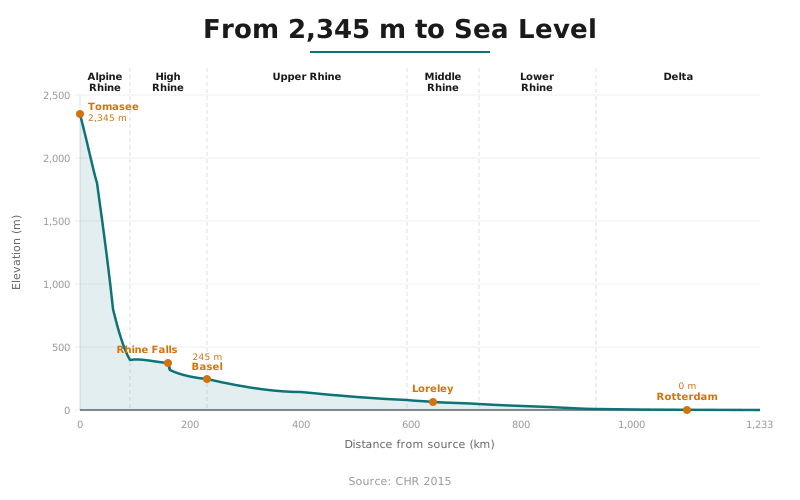
The Rhine descends 2,345 meters from Tomasee to sea level, but the distribution is anything but uniform. The Alpine Rhine accounts for roughly 225 meters of descent in just 90 km — a gradient of about 2.5 meters per kilometer. The High Rhine drops another 130 meters, including the spectacular 23-meter plunge at the Rhine Falls. By contrast, the Upper Rhine loses only about 35 meters over its entire 362-km course, and the Lower Rhine barely 10 meters across 212 km. The Dutch delta is essentially at sea level, influenced by tides rather than gravity.
This gradient profile determines everything: flow velocity, sediment transport, navigability and the type of infrastructure humans have built. Steep sections produce rapids and waterfalls suitable for hydroelectric power. Gentle sections create the slow, deep channels that barges need. The transition zone — the Middle Rhine gorge — is where these two regimes collide, creating the navigational bottleneck that has shaped Rhine shipping for centuries.
How the Sections Connect
No section of the Rhine exists in isolation. The glaciers and snowfields of the Alpine Rhine feed the discharge that carries cargo through the Lower Rhine. The sediment trapped in Lake Constance determines water clarity at Basel. The floodplains lost along the Upper Rhine increase flood risk at Cologne. And every drop of water that reaches the Dutch delta reflects the combined land use, industry and climate of all nine upstream countries.
For a broader overview of the river, return to the Rhine geography hub, or trace the full route on our Rhine map.