The Rhine River: Complete Guide to Europe’s 1,232 km Waterway from Source to Sea
A single drop of meltwater falls from a snowfield above Tomasee, a glacial lake perched at 2,345 meters in the Swiss canton of Graubünden. That drop will travel 1,232.7 km before reaching the North Sea near Rotterdam — passing through nine countries, supplying drinking water to over 30 million people, and carrying some 285 million tonnes of cargo per year. This is the Rhine, and in my years studying it, I have never stopped being struck by the sheer range of landscapes and human stories packed into a single river corridor.
Quick Facts: The Rhine at a Glance

1,232.7 km total length (Source: CHR, 2015) · 185,000 km² catchment area (Source: ICPR, 2024) · 9 countries · 58 million people in the catchment · 30+ million depend on Rhine drinking water · 884 km navigable for large vessels · 2,210 m³/s mean discharge at the Dutch border
Where the Rhine Begins: Tomasee and the Source Streams
The Rhine does not start as a single stream. Two headwaters — the Vorderrhein (Anterior Rhine) and the Hinterrhein (Posterior Rhine) — merge near the village of Reichenau in Graubünden to form the Alpine Rhine. The official source is Tomasee (Romansh: Lai da Tuma), a small lake at 2,345 meters above sea level, fed by snowmelt and rainfall from the surrounding peaks.
From Reichenau, the young river enters a broad valley shared by Switzerland, Liechtenstein and Austria. This section, called the Alpine Rhine, runs roughly 90 km before emptying into Lake Constance. Even here, the Rhine already carries a mean discharge of about 230 m³/s — enough force to have shaped the wide, gravel-filled valley floor over millennia (Source: CHR, 2015).
Lake Constance: The Great Pause
Before continuing north, the Rhine enters Lake Constance (Bodensee), a 536 km² basin shared by Germany, Austria and Switzerland. The lake acts as a natural sediment trap and hydrological buffer: water entering from the Alpine Rhine loses its sediment load and emerges cooler and clearer at the western end near Stein am Rhein. This “pause” matters for everything downstream — it smooths out seasonal flood peaks and stores water during dry spells.
Seven Sections, Seven Characters
Hydrologists divide the Rhine into seven distinct sections, each with its own gradient, geology and human use. The transformation from alpine torrent to tidal delta is dramatic:
| Section | Approximate Length | Character | Key Feature |
|---|---|---|---|
| Alpine Rhine | ~90 km | Steep gravel-bed river | CH/LI/AT border region |
| Lake Constance | — | Sediment basin, hydrological buffer | 536 km² shared by 3 countries |
| High Rhine (Hochrhein) | 141 km | Rapids and falls | Rhine Falls at Schaffhausen (23 m drop) |
| Upper Rhine (Oberrhein) | 362 km | Wide graben plain | Tulla straightening, 1817–1876 |
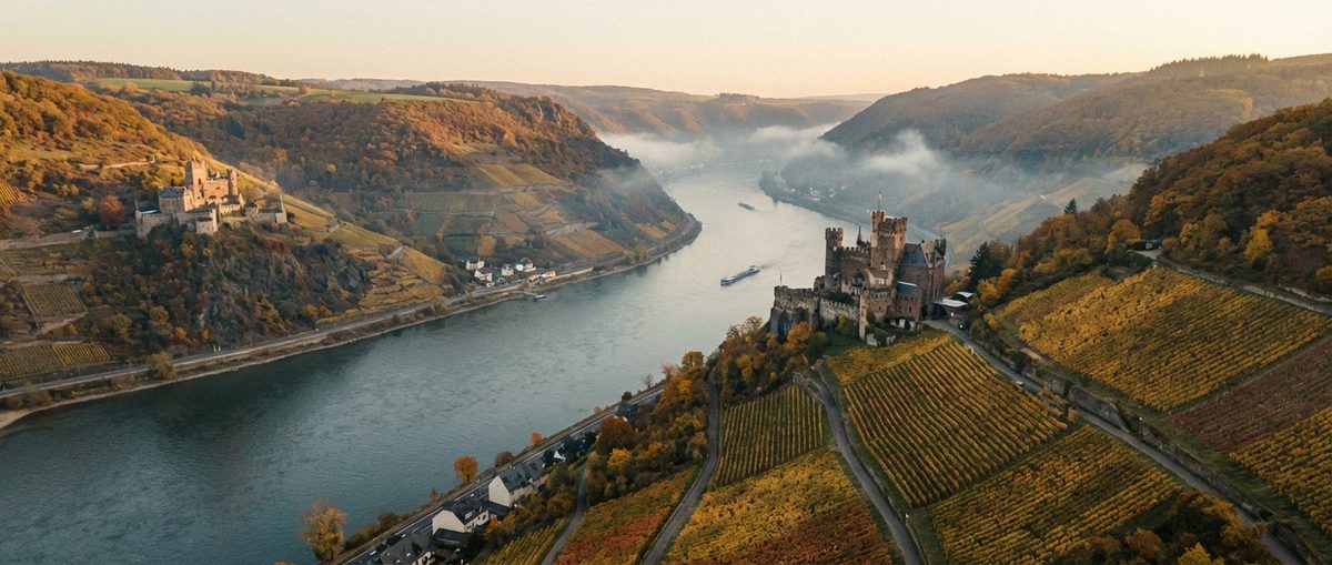
| Middle Rhine (Mittelrhein) | ~130 km | Narrow gorge, UNESCO World Heritage | Loreley narrows to 113 m |
| Lower Rhine (Niederrhein) | ~212 km | Industrial lowland | ~200,000 ships per year |
| Rhine Delta (Deltarhein) | ~50 km | Tidal delta, three branches | Waal carries 67% of flow |
Section lengths vary depending on boundary definitions. (Source: CHR, 2015; ICPR, 2024)
The Upper Rhine alone accounts for 362 km — nearly a third of the total length. It flows through the broad Rhine Graben, a geological rift valley between the Vosges mountains in France and the Black Forest in Germany. Here, the river was heavily straightened by engineer Johann Gottfried Tulla between 1817 and 1876, shortening its course and enabling large-scale navigation but destroying much of the original floodplain.
The Catchment Area: 185,000 km² Across Nine Countries
The Rhine’s catchment area — the total land area that drains into the river — covers 185,000 km² (Source: ICPR, 2024). That is roughly half the size of Germany. Nine countries share this basin:
- Germany — ~105,000 km² (~57%)
- Switzerland — ~26,800 km² (~14%)
- France — ~24,000 km² (~13%)
- Netherlands — ~24,000 km² (~13%)
- Luxembourg — ~2,400 km²
- Austria — ~2,366 km²
- Belgium — ~800 km²
- Liechtenstein — ~160 km²
- Italy — ~51 km²
Germany dominates with more than half the basin area, but the Alpine headwaters in Switzerland supply a disproportionate share of the water — especially during summer, when snowmelt drives discharge. The International Commission for the Protection of the Rhine (ICPR) coordinates water management across all nine nations, making the Rhine one of the best-governed international rivers on earth.
The Rhine Falls and the High Rhine
Before leaving Switzerland, the Rhine delivers one of Europe’s great natural spectacles. Near Schaffhausen, the Rhine Falls (Rheinfall) thunders 23 meters over a limestone ledge — making it the largest waterfall in Europe by volume. At peak flow in early summer, up to 600 m³/s of water crashes over the falls, generating a roar audible from hundreds of meters away. The falls exist because of the last ice age: glacial deposits forced the Rhine to carve a new channel over harder rock, which it has not yet eroded through.
Below the falls, the High Rhine continues 141 km westward along the Swiss-German border, studded with hydroelectric power stations. Eleven run-of-river plants between Lake Constance and Basel produce substantial electricity. Further downstream, the Rheinkraftwerk Iffezheim on the Upper Rhine generates 860 GWh per year with a capacity of 146 MW — making it Germany’s largest run-of-river power plant (Source: EnBW). In total, the ten major hydroelectric stations along the Upper Rhine produce approximately 9 billion kWh annually.
Discharge: How Much Water Flows?
The Rhine’s discharge — the volume of water passing a given point per second, measured in cubic meters per second (m³/s) — grows steadily from source to mouth. At Basel, the mean discharge is 1,040 m³/s. By the time the river crosses into the Netherlands at Lobith, it has swelled to 2,210 m³/s (Source: BfG/Undine). The combined flow of all delta branches reaches roughly 2,900 m³/s at the North Sea.
These numbers mask enormous variation. During the extreme low water of October 2018, discharge at Kaub fell to 544 m³/s — barely a third of normal. The Cologne gauge hit a record-low water level of just 69 cm (Source: BfG/Undine). Conversely, during the catastrophic flood of January 1926, discharge at Lobith peaked at 12,600 m³/s, roughly six times the average.
Snowmelt accounts for approximately 39% of annual discharge at Basel. In extreme droughts, glacier melt can contribute up to 30% of flow — making Alpine glaciers a critical buffer for the entire river system. (Source: CHR Snow & Glacier Melt Synthesis, 2023)
Major Tributaries: The Rivers That Feed the Rhine
The Rhine does not become Europe’s busiest waterway on its own. Eleven major tributaries feed into it, each draining significant portions of Central Europe. The most remarkable is the Aare, which at 560 m³/s mean discharge actually carries more water than the Rhine itself at their confluence near Koblenz, Switzerland (Source: CHR, 2015).
Further downstream, the Neckar joins at Mannheim (145 m³/s), the Main at Mainz (225 m³/s) and the Moselle at Koblenz, Germany (328 m³/s). The Main is especially significant because, since 1992, it has been connected to the Danube via the Main-Danube Canal, creating a continuous waterway from the North Sea to the Black Sea.
Significance: Why the Rhine Matters
Drinking Water for 30 Million People
Over 30 million people draw their drinking water from the Rhine or its groundwater-connected aquifers (Source: ICPR, 2024). Dutch cities like Amsterdam and The Hague depend on Rhine water filtered through dune infiltration systems. German cities along the Upper and Lower Rhine pump river-bank filtrate — groundwater that has passed through soil layers near the riverbank.
Europe’s Busiest Inland Waterway
In 2024, vessels transported 284.5 million tonnes of cargo on the Rhine between Basel and the North Sea — a 2.6% increase over the previous year (Source: CCNR, 2025). The Rhine accounts for 80–86% of all German inland waterway freight. At the Lower Rhine alone, some 200,000 ships pass each year. The Port of Duisburg, the world’s largest inland port, handles 50.8 million tonnes and 3.9 million TEU containers annually (Source: Duisport, 2024).
Ecology Under Pressure — and Recovery
The Rhine has seen both its lowest point and one of Europe’s greatest environmental comebacks. After the Sandoz chemical disaster of November 1, 1986 — when 20–30 tonnes of toxic agrochemicals washed into the river near Basel, killing virtually all life along 180 km — governments invested over 80 billion euros in wastewater treatment across the catchment (Source: AquaPedia; ICPR). Today, 71 fish species live in the Rhine again, including returning Atlantic salmon (Source: ICPR, 2024). But challenges remain: ecological status under the EU Water Framework Directive is rated “good” in 0% of the main river channel, and invasive species dominate up to 90% of the riverbed fauna in some stretches.
Culture and Heritage
The Rhine is inseparable from European culture. The 65 km Upper Middle Rhine Valley between Bingen and Koblenz became a UNESCO World Heritage Site in 2002, recognized for its roughly 40 castles and its role in the Rhine Romanticism movement. The Loreley rock — where the river narrows to just 113 meters — inspired Clemens Brentano (1801) and Heinrich Heine (1824) to create one of Germany’s most enduring literary myths.
The Rhine Delta: Where the River Meets the Sea
At the Dutch border, the Rhine splits into three branches. The Waal carries 67% of the discharge, the Nederrijn/Lek takes 22%, and the IJssel diverts 11% northward. The delta is heavily managed through weirs, locks and storm surge barriers — the Dutch have engineered these waterways for centuries, and today the system protects millions of people living below sea level.
The Port of Rotterdam, at the western end of the Waal, is Europe’s largest seaport with a total throughput of 435.8 million tonnes in 2024 (Source: Port of Rotterdam, 2025). It generates an estimated 45.6 billion euros in economic value — 6.2% of the Netherlands’ entire GDP.
Looking Ahead: Climate Change and the Rhine’s Future
The Rhine of 2040 will not be the Rhine of today. Water temperatures at Basel have risen by 0.4°C per decade since 1978, and projections under high-emission scenarios point to increases of 2.9–4.2°C by 2100 compared to the 1990–2010 baseline (Source: ICPR Technical Report 302, 2025). Summer discharge could decline by up to 25%, while winter flows are expected to increase — making both floods and droughts more severe.
The ICPR’s “Rhine 2040” program sets ambitious targets: restoring 200 km² of floodplains, reconnecting 100 oxbow lakes, creating 400 km of more natural riverbanks, and reducing micropollutants by 30% (Source: ICPR, 2024). These goals will shape the Rhine’s geography as profoundly as Tulla’s straightening did two centuries ago — but this time, the aim is to give the river room, not take it away.
A River of Extremes
The Rhine is a river of contrasts. Its source lies in one of Europe’s most pristine Alpine landscapes; its lower course passes through one of the continent’s most industrialized regions. It hosts 71 fish species — a remarkable recovery — yet invasive round gobies now make up over 93% of fish catches at some Lower Rhine stations (Source: PLOS ONE, 2024). It carries more cargo than any other European inland waterway, yet three of the four worst low-water events in its recorded history occurred in the last 25 years (2003, 2018, 2022).
BASF’s chemical complex at Ludwigshafen — the largest contiguous chemical site in the world, covering 10 km² — draws approximately 5 million cubic meters of Rhine water per day for cooling (Source: BASF). During the 2018 low-water crisis, the company lost an estimated 250 million euros because barges could not deliver raw materials (Source: BASF Q4 2018). The wider economic ripple effects reduced Germany’s GDP by an estimated 0.4% per month during the worst phase (Source: IfW Kiel). These extremes underscore why understanding the Rhine’s geography matters — not just academically, but for the 58 million people whose economies, water supplies and daily lives depend on this single river corridor.
Explore the Rhine’s geography in depth: follow its course from source to sea, learn how each river section differs, discover the tributaries that feed it, and understand how nine countries share this extraordinary river. For the Rhine’s living systems, visit our ecology section. For its role in commerce, see shipping and navigation.
Sources & References
- International Commission for the Protection of the Rhine (ICPR): The Rhine — Facts & Figures
- Commission for the Hydrology of the Rhine (CHR): Length of the Rhine — Update 2015
- Federal Institute of Hydrology (BfG): Undine — Rhine Discharge Data
- Federal Waterways and Shipping Administration: Bundeswasserstraße Rhein
- ICPR: Drinking Water from the Rhine
- Duisport: Port of Duisburg — World’s Largest Inland Port
- EnBW: Hydroelectric Power on the Upper Rhine